HTZ Warfare and HTZ Communications - Latest Features and Updates
These features are available with the latest upgrade (HTZv2025.2) and can be accessed via the CRM. If you do not have a valid maintenance contract and wish to access the latest updates, please contact your local office for more information.
Interface
Station Icons Support - Users can now assign 48x48 PNG icons to stations for improved visual representation. PNG files must be placed in the /Base//Pics folder, and the "PNG 48x48" option must be selected under Object Properties (F5).
Measurement Point Relocation - The "Move to clutter code #" option allows measurement points to be relocated based on specific clutter codes, ensuring more accurate data alignment.
Tree view - Isolate objects by type of station.
Export Google Earth – New info field selector.
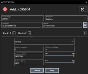 Add Tx/Rx from list – new selector: HTZ warfare only
Spectrum Management
USA Border Data Update - The USA_adm0 border vectors have been converted from Multi-part to Single-part polygons for improved accuracy and efficiency. Updated files are included in the "/Borders" folder of the installation package.
Calculations
3D Coverage Calculation Enhancement - new vertical (Z-axis) calculation step enables coverage calculations from the ground level to the top of each building, with a user-defined step in meters.
Custom Calculation Ranges for CCTV - Maximum calculation distance and DRI distance for CCTV coverage can now be customised by users, providing greater flexibility in coverage analysis.
Interlaced servers – Station comparison by overlapped coverage
New lateral diffraction model – Enhanced UTD method
NEW: HTZ Web API functions:
For more details, visit the customer portal for the latest update.


