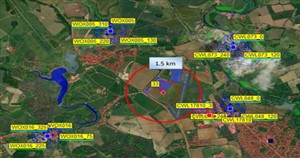
Electromagnetic Spectrum (EMS) is widely used for military operations. Competing demands for the radio spectrum means it's strictly coordinated and controlled. Battlespace spectrum management is the planning, coordination and management of EMS to allow military systems to perform their functions without causing or suffering from harmful interference. ATDI's flagship EW planning tool, HTZ Warfare, specialises in electromagnetic deconfliction.
Significant importance is placed on the performance of radio intercept receivers, direction finders and communications jamming equipment. Mission success often relies on the ability to intercept or jam enemy communications. And, to share information with the command structure without undue interference.
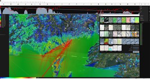
HTZ Warfare enables users to exploit spectrum-dependent systems, including communication links, electronic warfare sensors, radio jammers and radar detection. This radio propagation software solution is recognised around the globe by military, government and security organisations.
ATDI is a leading military network planning and EW modelling specialist. Our flagship radio propagation software, HTZ Warfare supports military units around the globe. This solution enables military units, defence and security agencies to design communication networks, minimise interference, automatically assign frequencies and generate alternative communication plans.
Key product features include:
HTZ Warfare removes the complexity from calculations in the field and simplifies the user experience intuitively across a wide range of applications, including:
Airports use an abundance of wireless technologies to connect passengers, devices, safety-critical systems, and aircraft. ATDI specialise in three types of communication systems: ground communications for controlling operations, ground-to-air communications for managing airspace and radars for monitoring en-route operations.
HTZ is technology-neutral allowing it to model almost every wireless technology. It features dedicated functions, including:
Key features include:
ICAO Building Heights: This function computes the max. building heights on each point of the map, for seen and not seen points. This automatically checks the max clearance and then re-calculates a new dataset based on the ASCII-GRID format. Essential when modelling the impact of new buildings on Radars and other airport comms equipment.
Exclusion zones: This function supports coexistence modelling between 5G and radio altimeters by calculating the min. the separation between bands, taking into account the digital terrain model, buildings, flight path and flight height and the 5G network deployment. Once parameters are input, including propagation modelling, transmission power and antenna height, pattern and tilt, the uplink signal to the radio altimeter can be modelled.
Multilateration: The MLAT function calculates the location of an aircraft accurately. TDOA calculates the time difference between the signals received by multiple sensors, while TSOA calculates the time synchronization of the signals received by multiple sensors. Both methods reduce errors in locating aircraft and enhance tracking accuracy. HTZ uses advanced algorithms to calculate the location of the aircraft with the TDOA and TSOA methods to improve the accuracy of results.
Localization: The localization accuracy map featured in HTZ, allows the user to determine the localization accuracy of a network consisting of Direction Finders. These detect the best possible locations for virtual transmitters located on the map.
Indoor modelling: HTZ Communications models communications inside terminals and hangers and supports multiple technologies, including WiFi 6. HTZ features an ITU propagation model for indoor environments and allows the user to specify building materials in the settings.
This tutorial looks at the interaction between 5G towers and radio altimeters on aircraft.
The tutorial calculates the exclusion zone needed around the airport to enable MNOs to decide where to deploy 5G towers.
Check out our Blog on microwave links versus flight altitude analysis.
5G networks offer increased capacity, lower latency and faster speeds. They can operate in the higher frequency bands between 28GHz and 60GHz in a band known as the millimetre wave (mmWave) spectrum. 5G networks feature dense, distributed networks of base stations or small cells. 5G networks offer ultra-reliable, low latency capacity, which supports a growing number of user applications. Our flagship radio planning tool, HTZ enables MNOs to plan, model and optimise their radio networks.
Small cells in 5G networks increase network data capacity and can reduce rollout costs by eliminating expensive rooftop installations. 5G networks feature built-in flexibility to support coexistence with other standards like LTE & Wi-Fi and to enable spectrum sharing.
Because 5G operates in high-frequency bands, accurate cartographic data is needed to consider the terrain, clutter heights and building which may impact the service, network latency and capacity. ATDI offers access to a comprehensive library of map data, available for download for customers with a valid maintenance contract. These high-resolution maps support signal loss modelling which is characterised by the geo-spatial environment and identify buildings and clutter that impact mmWave propagation.
5G networks offer three distinct use cases for industry, each offering its own distinct benefits to users, communities and industry as a whole.
This tutorial gives a high-level overview of the features and functions available in HTZ Communications & HTZ Warfare.
View our 3-part 5G network planning webinar.
Often technology advancements and deep pockets win wars. However, good communication networks in the battlespace can be the difference between military success or failure. Nowadays, ministries of defence are compelled to assess their radio spectrum use to ensure their spectrum management practices reap maximum benefits.
Defence & security communications have been an integral part of ATDI since its outset. The scope of this work ranges from auditing the use of military spectrum to advising and supporting studies on coexistence, releasing spectrum for commercial use and the reallocation of spectrum for reuse with other technologies.
HTZ Warfare offers dedicated features for the defence and security markets including:
HTZ Warfare supports all technologies and functions for the defence and security markets, including:
Check out how Drones are used in the military and defence sectors.
HTZ Communications
As the use of drones or unmanned aircraft (UAV) grow, businesses and Governments are seeing significant demand and growth in areas like transport, military, logistics and commercial sectors.
Drones are controlled by a ground control system (GSC) which operates remotely or autonomously. Wireless connectivity lets pilots view the drone and its surroundings from a birds-eye perspective. Users can also leverage apps to pre-program specific GPS coordinates and create an automated flight path for the drone.
The data links use a radio-frequency (RF) transmission to transmit and receive information to and from the UAV. These transmissions share information like location, distance and location to target, distance to the pilot, payload information, airspeed, altitude and more. An autonomous drone can conduct a safe flight without the intervention of a pilot.
HTZ Communications offers dedicated features for drone management including:
HTZ Warfare
In the defence and security sector, UAVs are used as target decoys, for combat missions, research and development. Their growing use has reduced losses in the field and enables the execution of high profile and time-sensitive missions.
Anti-drone systems are used to detect or intercept unwanted unmanned aerial vehicles. More often, anti-drone technology is deployed to protect areas like airports, critical infrastructure, large public spaces and military installations and battlefield sites.
Counter-drones are used to jam the signal between the drone and drone pilot.
Check out our Counter-drone demo today.
Electromagnetic Spectrum (EMS) is widely used for military operations. Competing demands for radio spectrum means it must be strictly coordinated and controlled. Battlespace spectrum management is the planning, coordination and management of EMS, to enable military systems to perform their functions without causing or suffering from harmful interference.
Significant importance is placed on the performance of radio intercept receivers, direction finders and communications jamming equipment. Key features that determine the success of a mission is the ability to intercept or jam enemy communications. And similarly, to share information with the command structure without undue interference.
With over three decades of development, HTZ Warfare is a leading military network planning and EW modelling tool. This feature-specific software supports military units around the World. Key functions include:
HTZ warfare removes the complexity of calculations in the field and simplifies the user experience intuitively across a wide range of applications, including:
Check out our BSMS company presentation.


