These features are available in the latest upgrade (HTZv2025.4) and can be accessed via the CRM. If you do not have a valid maintenance contract and wish to access the latest updates, please contact your local office for further information.
INTERFACE
Function Name: Station Link via Popup Menu (1-way/2-way)
Users can now link stations directly using station numbers, streamlining point-to-point network design.
Function Name: Map Layer – HERE Server Support
The maximum number of data pings for HERE map servers has been increased for improved reliability.
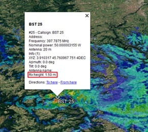 Function Name: Export to Google Earth – Site-by-Site Coverage
Each station’s coverage export now includes its receiving antenna height, improving detail and clarity in Google Earth outputs.
Function Name: Geocoding to DTM Layer
A new option allows users to retain the minimum elevation or indoor value during raster import, improving terrain data consistency.
Function Name: Interface Design Enhancements
UI improvements enhance compatibility with various Windows versions, ensuring a smoother user experience.
Function Name: Text Vector Display
Locations of text vectors can now be displayed on the map using the same colour as the vector text background.
Function Name: Station Treeview Navigation
Double-clicking a station in the tree view automatically centres the map cursor on its location
Function Name: GPS Coordinate Precision
Support for up to 5 decimal digits in GPS coordinate format (ddmm.mmmmm) has been added.
SPECTRUM MANAGEMENT
Function Name: ICS Manager noDB – BRIFIC Support
The latest release now supports the updated BRIFIC format, aligning with ITU documentation from version BRIFIC 3042 onward.
CALCULATIONS
Function Name: Clutter Settings – dB/km Model Enhancements
Revised models improve how attenuation is calculated through vegetation and buildings, offering more realistic results based on terrain and environmental conditions.
TACTICAL COMMS
Function Name: Map Layers – MaXar URL Update
URLs for MaXar servers have been updated, ensuring continued access to high-resolution tactical mapping layers.
For full documentation and further support, please contact your local ATDI office or visit our customer portal.


