We’re pleased to bring you a packed update this month, covering the latest enhancements, projects, and insights from across our work in wireless communications and beyond. Whether you’re interested in the newest features within HTZ, such as our cutting-edge AI Mask Prediction tool, or want to learn how we’re supporting the Port of London with advanced modelling and analysis, there’s something here for everyone.
You’ll also find highlights from ongoing academic research into AI-driven coverage prediction, a new video showcasing our wind farm mitigation work, and a snapshot of our activities in the railway communications sector, including our latest flyer.
Take a few moments to scroll through the articles and stay up to date with our most exciting news and innovations—designed to keep you informed and inspired.
 HTZ continues to evolve, with new features and modifications designed to enhance the user experience, improve RF analysis capabilities, and support critical spectrum management tasks.
CALCULATIONS
TOOLS/HF propagation
A new “Move to my location” function now updates the station heading (azimuth) based on GPS or system location data.
INTERFACE
REPORT/Area file
Points below the polygon contours are now included in area/vector analysis, improving the precision of coverage reports.
TOOLS/Cartographic conversion
The integration of new GeoConv DLLs enhances map format compatibility and conversion.
RIGHT-CLICK ON MAP / Convert coordinates
The coordinate converter is now accessible directly via map right-click, mirroring the functionality found under “Tools”.
SHORT BUTTON / Export screen
A new AI model improves PNG tile and mask export predictions for visual outputs.
COVERAGE / Search sites
Enables polygon-based site search using “Info(1)” field logic for source and destination matching.
RECTANGLE & POLYGON TOOL / Search site
Updated with a new dialogue box to simplify site search and selection workflows.
Move to my location (Windows Service)
The priority logic has been updated to prefer GPS input; if unavailable, the system defaults to Windows location services.
SPECTRUM MANAGEMENT
RADAR STATION POPUP MENU / Coordination
Introduces PSR/SSR safeguarding zones in line with EUROCONTROL guidance for assessing wind turbine impacts on radar.
SPECTRUM / Constraints
Calculates areas where structures (e.g., wind turbines) meet clearance angle constraints around active stations.
STATION DATABASE / Export ICS-M
Allows station data export to ICS Manager for continuity between planning and licensing environments.
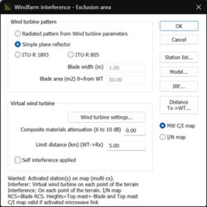
STATISTICS / COVERAGE MAP / Wind turbine exclusion area
Adds MW C/I interference mode to improve exclusion area assessments for wind farms.
TACTICAL RADIO COMMS (+INTERFACE)
C.E.W / JAMMING / STATIC / Jamming efficiency (J/N)
This feature introduces a new reporting function, facilitating tactical planning and analysis.
MAP LAYER UDATES – <F4> and <F8> Shortcuts
URLs for Maxar imagery have been refreshed; Bing Maps are no longer supported within Map Quad.
Access the latest updates here.
 Explore the latest cartographic datasets now available. These royalty-free datasets are a valuable addition to your cartographic toolkit and are accessible through the customer portal. Here's a summary of the data resolutions and their locations:
1m resolution: DTM/Clutter/Buildings: UK: Easington, Norway: Setermoen, USA: Freeport (TX)
2m resolution: DTM/Clutter/Buildings: USA: Chicago Airport (IL), Los Angeles (CA) and Fairfax (VA)
10m resolution: DTM/Clutter/Buildings: Germany: Rheinland-Pfalz
10m resolution: DTM/Clutter: Japan, Northern Mariana Islands, Pacific: Marshall Islands, Nauru, Rarotonga, Tuvalu.
20m resolution: DTM/Clutter: Syria, Iraq, Pacific: Kiribati + Salomon
20m Population: Belgium
100m resolution: Conductivity: Bulgaria
100m population: French Polynesia: population and CP
We continually refresh our map data library to guarantee your access to the most current maps. Stay tuned for updates!
Access the latest updates here.
ATDI announces a significant upgrade to AI Mask Prediction, its intelligent tool for refining cartographic data. This new release marks a leap forward in map automation, driven by a state-of-the-art deep learning architecture that delivers over 93% accuracy across continental regions.
AI Mask Prediction now directly detects, from satellite imagery, trees and buildings likely to cause radio signal diffraction, enabling RF planners to build more accurate models from the outset. The enhanced model improves on the original by offering faster and more precise data extraction, thereby boosting the quality of coverage predictions, interference analysis, and network optimisation.
A key benefit is that it runs efficiently on both CPUs and GPUs, making it accessible even with low-spec hardware. Combined with the ability to generate high-resolution maps in-house, this tool helps reduce manual workload and provides precise, current inputs for RF planning and optimisation.
This powerful update is now available in the latest version of HTZ, helping engineers enhance accuracy and model with confidence.
To access the latest update, click here.
 Wind turbines can interfere with radar systems, posing challenges for aviation and defence operations. This video outlines a structured, EUROCONTROL-based methodology for assessing such impacts. The two-phase process begins with a quick screening to determine potential interference based on turbine height, distance, and line of sight. If needed, a detailed technical evaluation follows, including propagation modelling and radar performance analysis. This phased approach enables stakeholders, including regulators, radar operators, and wind farm operators, to identify risks early and implement effective mitigation strategies. It ensures radar integrity while supporting the safe expansion of renewable energy infrastructure.
View the video here.
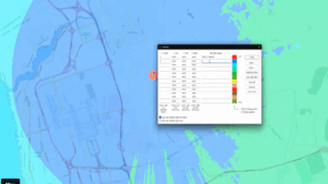
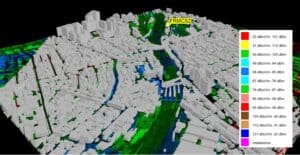
 As one of the UK’s busiest waterways, the Port of London depends on reliable AIS coverage to manage vessel traffic. With riverside developments on the rise, the Port of London Authority (PLA) commissioned ATDI to assess the potential impact on AIS performance.
Using HTZ Communications, ATDI modelled signal obstructions and proposed mitigation strategies such as optimised site placement and antenna adjustments. The study compared modelled results with known performance baselines to validate coverage resilience under real-world conditions.
The final report provides technical assurance to the PLA and supports informed discussions with planners. The complete project file was delivered to the Authority, enabling future updates using their licensed HTZ software.
For the full article, click here.
![]() Artificial Intelligence is transforming how we design and manage radio communications. From predicting coverage to automating interference analysis, AI is helping network operators, regulators, and researchers optimise performance and speed up decision-making.
Artificial Intelligence is transforming how we design and manage radio communications. From predicting coverage to automating interference analysis, AI is helping network operators, regulators, and researchers optimise performance and speed up decision-making.
A great example comes from Stellenbosch University in South Africa, where a postgraduate researcher is using HTZ Communications to generate thousands of RF coverage maps for training a machine learning model. The study explores how simplified radio zone maps, analysed with generative adversarial networks (GANs), can predict radio coverage without relying on complex base map data. The project utilises advanced propagation models, such as ITU-R P.526, and high-resolution terrain data to simulate realistic conditions across various environments.
This academic study shows how HTZ can support innovative applications beyond traditional planning, reinforcing its flexibility and value in AI-driven research.
ATDI continues to invest in AI to enhance RF planning. Our AI-powered radio signal identification model accelerates real-time spectrum analysis by automatically classifying signals, eliminating the need for human input. Meanwhile, the AI Mask Prediction feature extracts detailed cartographic data from satellite imagery and terrain maps, ensuring better accuracy in network simulations.
As the sector shifts toward more innovative, more adaptive systems, integrating AI into tools like HTZ will play a critical role in shaping the next generation of connected, mission-critical communications.
For the full article, click here.
 ATDI recently returned from Middle East Rail in Dubai, where we connected with infrastructure operators, regulators, and technology providers from across the region. As rail networks expand and modernise, the industry faces increasing complexity, particularly in managing mission-critical communications that are both reliable and future-proof.
A key topic of discussion was the transition from legacy technologies, such as GSM-R and TETRA, to next-generation platforms, including LTE-R and FRMCS. This shift presents challenges related to interoperability, spectrum coexistence, and the performance of hybrid networks operating across diverse environments—from open countryside to tunnels, bridges, and densely populated urban areas.
At the event, ATDI showcased how our flagship tool, HTZ Communications, enables rail operators to manage the full lifecycle of radio network planning and optimisation. Its versatility allows engineers to work across multiple technologies—DMR, TETRA, P25, LTE-R, FRMCS within a single project, streamlining planning, reducing coverage gaps, and ensuring systems meet both operational and regulatory demands.
To learn more, download our new HTZ Railways brochure and discover how ATDI is helping rail networks stay connected, resilient, and ready for the future.


