Customer: DGAC, French Civil Aviation Authority
Location: France
Analysing potential cross-overs between MW path profiles and flight paths. With a growing focus on air safety, this case study looks at how airlines, airport operators and civil aviation authorities need to comply with international air traffic safety regulations.
The project looked at the viability of predefined microwave links and potential intersections between the Fresnel zone of each beam and flight paths.
This study was undertaken at two French airports, with the proposed links using three different frequency bands. The aircraft positions were based on the civilian flight corridors and included take-off and landing. The analysis incorporated jumbo jet class carriers, which feature a tall tail section that has the potential to cross or partially obstruct the microwave link path.
A French service provider was tasked with installing new microwave links at two international airports. These links were located inside the perimeter at the control tower, near the runways and in the surrounding area. The study assessed the impact of flight corridors on the MW links, including;
ATDI implemented the 'MW link versus flight altitude' function in HTZ to allow the team to check for potential cross-overs between the path profiles of each link and the flight paths. Initially, they created a 16bit raster-layer or IC2 raster file from SHP polylines, which contained the flight track elevations. HTZ uses these files to identify any transmission losses while the aircraft was taking off and landing. Further checks assessed whether the Fresnel zone was below or above the flight corridor. Only those that crossed the flight corridor required further analysis. The team performed the link path budgets and reliability analysis, which took into account existing obstacles (building, forests).
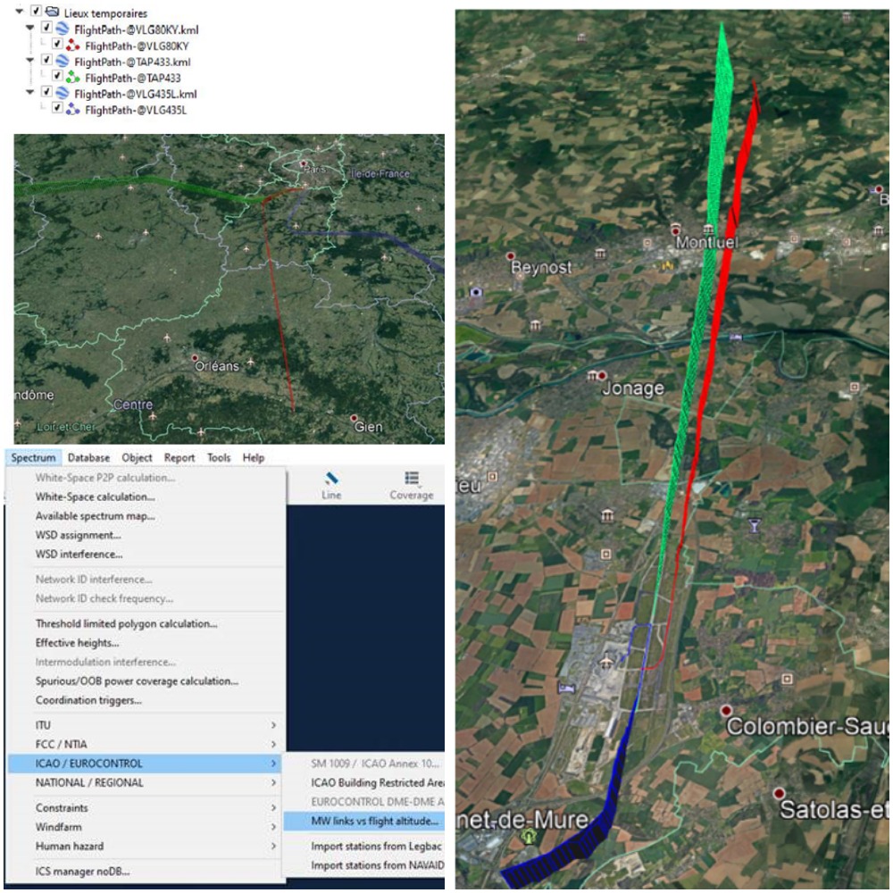
To achieve the desired results, the team created a high-resolution map data set. The mapping featured a 2.5m digital terrain model and clutter/buildings layer. The Civil Aviation Authority provided the flight tracking details, which consisted of altitude corrections corresponding to daily QNH (mean sea level atmospheric pressure) readings.
The final report allowed the DGAC, the French Civil Aviation Authority, to approve a permit application for the new MW links. DGAC are responsible for ensuring the safety and security of French air transport.
Line-of-Sight Microwave links should have sufficient clearance over any object or terrain along the path to avoid signal grazing or scraping across obstacles. The Fresnel zone is the area around the visual line-of-sight that radio waves spread into after they leave the antenna, and where obstacles would cause in phase or out of phase reflections of the radio wave.


