February has been non-stop. This year, alongside our annual Spectrum Management Summit, we hosted for the first time, an Electronic Warfare Summit. Both events were a resounding success, and the recordings are now available. Our next event is a Workshop on Drone-based antenna measurements: techniques for predictive modelling and verification. Registration is open. Unable to attend? Register and you automatically receive the recording link.
This month’s Newsletter looks at the latest updates to HTZ and calculates coverages at different flight heights for drone networks to identify network not-spots. We also look at how aviation authorities mitigate risk from wind farms in their airspace. Lastly, we're attending a number of expos in the US, Japan and Malaysia. If you plan to attend those events, pop down and say hello to the Team.
This month's product videos cover the latest features supporting WiFi 6 and Non-GSO satellites, use the links below. We also have a wealth of other new and improved features listed in the attached PDF.
Upgrades are available to all customers with a valid Maintenance contract and are accessible via the Customer portal. For any technical support questions, please contact the technical engineering team.
WiFi-6
This video looks at the indoor modelling function in HTZ, including the propagation model and settings to specify building materials.
Non-GSO Satellites
This video looks at how to add different satellites based on their beams and orbital inclination. The demo includes how to convert IFIC notices into HTZ format using ICS Manager no-DB. This module is accessible free of charge to all HTZ users with a valid Maintenance contract.
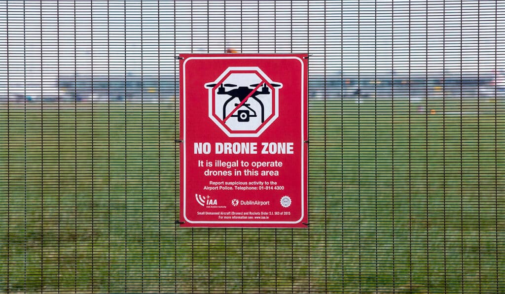
The true scale of illicit drone activity is unknown. In 2021, over 6,000 incidents were reported to Police in the UK alone. Threats presented by illegal drone activities include the unlawful filming of live sporting or entertainment events, contraband deliveries to prison inmates, intrusions into flight restriction zones at airports, military and nuclear facilities and hostile reconnaissance often used by organised crime. To protect sensitive areas from these illicit activities, authorities are turning to ATDI to ensure their jammers and counter-drone activities are optimised to reduce the risks of incursions and threats in their airspace.
Counter-drones and jammers intercept unmanned aircraft or UAVs while in flight. Drone operators must calculate their network coverage and identify not-spots across their network to reduce the risk of lost comms. Operators undertake in-depth analysis to understand the signal strengths from the controller to the drone based on different elevations across the network. Termed a counter-drone efficiency analysis, this calculation provides the network coverage based on various height elevations or potential flight paths of the unauthorised UAV. These coverage calculations identify areas with poor signal coverage resulting from topography and building heights which could restrict the ability to block or jam signals.
Check out our latest webinar recording on Managing drones - modelling coverage and DF and jammers. This is Session 4 (1:31:00).

When a Taiwanese electric company wanted to roll out a wind farm, the national Civil Aviation Authority turned to ATDI for help. They needed to understand the impact of the proposed wind farm on their ATC radars which sat directly under the flight path of air traffic. The CAA needed to simulate the effects of interference on their ability to communicate with planes.
Groups of wind turbines often appear as clutter to the ATC radar system, creating cluttered zones and making it difficult to track planes as they fly over. This safety concern is often costly and time-consuming for airports, which need to mitigate the effects and challenge planning permission requests for these developments.
Pierre Coutey, Senior Engineer at ATDI said, “HTZ incorporates recognised ITU propagation models to simulate the impact of turbines on aeronautical radars and other communications equipment. These proven models allow us to analyse the effects of potential interference.”
Using HTZ, the aviation authority can evaluate the impact on radars and surrounding telecommunications equipment and offer mitigation solutions to reduce the impact. HTZ supports windfarm mitigation analysis, which identifies whether a development is detected and if it adversely affects the ATC radar. Using C/I interference maps, users can identify obstructions caused by the wind turbines, and provide a clearance analysis for the potential interactions between the turbines and other equipment like weather radars. This analysis identifies three interference criteria in the near-field zone, diffraction and signal reflection.
For more information on this functionality in HTZ, contact your local office.
8 March 2023 - 11.30am UTC +8 Kuala Lumpur, Malaysia
This workshop analyses how measuring antenna patterns can improve network performance, support prediction correlation and allow model tuning. Together with Australian Drone-measurement company Sixarms, ATDI will demonstrate how antenna patterns and field measurements can validate network coverage across wide areas using their flagship RF planning and modelling tool, HTZ Communications.
The event covers the entire lifecycle of network measurement and analysis. The demo will show how radio power can be analysed and validated, outline the workflows and processes and identify the equipment and processes needed to visualise the data. The broadcast, defence and telecom industries all benefit from collecting measurement data this way.
The workshop shows how coverage measurements are validated using field strength measurements, along with prediction correlations and actual measurements.
Program:


