Happy New Year from the team!
This month’s newsletter looks at our upcoming Spectrum Management and Electronic Warfare summits. These half-day online events run consecutively on 14-15 February and are open to the industry.
We have spotlighted two customer use cases: radar mitigation on the River Thames and sound coverage analysis function in HTZ used to upgrade a WWII siren system in Germany. We review the tropospheric link analysis function in HTZ, which will be a focus of a session in the upcoming EW Summit.
Lastly, our event calendar for the first quarter is pretty full. Remember to check out our speaking slot at the EW Symposium in the USA and our workshop at the ABU DBS in Malaysia.
We look forward to welcoming you to the industry summits. Unable to attend? Register today to receive the recording links.
ATDI extends a warm invitation to our upcoming events. This year we are offering two half-day Summits focusing on topical issues relating to spectrum management and electronic warfare. The online sessions combine presentations and live demos from subject experts across the industry and the ATDI team.
Attendance is free. Please register in advance.
Delegates are encouraged to register for the sessions in their time zone.
Unable to attend? Register today to receive the event recordings. The program details are available via our website.

Tuesday 14 February - 09.30hrs CET / 13.00hrs EST/US / 10.00hrs PST
Register for Session 1: 09.30hrs CET
Register for Session 2: 13.00hrs EST/US / 10.00hrs PST
Full program here. http://atdi.com/civil-spectrum-management-summit/

Wednesday 15 February - 09.30hrs CET / 13.00hrs EST/US / 10.00hrs PST
Register for Session 1: 09.30hrs CET
Register for Session 2: 13.00hrs EST/US / 10.00hrs PST
Full program here. http://atdi.com/electronic-warfare-summit/
As river traffic increases so do the demands to manage important waterways like the Thames Estuary. The Navigation Systems team at the Port of London Authority (PLA) recently purchased HTZ Communications to ensure their comms networks were interference-free and fit for purpose.

Tasked with supporting the Authority’s VHF, DMR, UHF, radars and CCTV infrastructure, the team primarily uses the software to manage microwave links along the river, including point-to-point microwave budgets and modelling the impact of proposed high-rise buildings on LOS links. To ensure the team hit the ground running, they undertook a two-day custom training course covering all the technologies used by the Authority. The user training included:
David Barnard, Technical Support Engineer at the PLA, said “Managing multiple comms networks along the river needs a multi-technology network planning and modelling tool. With HTZ, we can manage all our existing radio networks with one piece of software. As technologies advance, we’re in a strong position to assess, plan and model emerging technologies to support the demanding communication needs of the Authority.”
David and his team currently use the software to identify the optimal sites for radio equipment and to analyse radar coverage along the river.
The PLA are the guardians of the River Thames in London. Covering over 95 miles of the river from Teddington to the North Sea, the Authority is responsible for ensuring the safe passage of commercial and leisure users, protecting trade and travel, and safeguarding and enhancing the environment. To support this activity, the Authority operates several radar sites providing detailed coverage of the river, AIS sites for collision avoidance, sensor networks for tidal information and weather updates and microwave and networking infrastructure.
For more information visit: www.pla.co.uk
The recent incline in the weather highlighted a growing need to alert the public to flood warnings. Add to that the potential threats posed by the War in Ukraine, the German federal government and associated German states identified a need to update the existing post-Cold War sirens.
The local authorities installed new digital siren systems that were funded by an 88 Mio EUR-backed funding program. Electronic sirens support power control with the option to change signal direction and manage speech transmissions. The responsibility for simulating how the sound from this new system propagates fell to ATDI’s flagship modelling tool, HTZ. Featuring a Sound coverage calculator, users calculated the impact of different terrains, building density, signal strength, heights of emitters and the siren system configuration on sound propagation. These simulation results reflect the different heights of the emitting installation, power direction and minimum sound levels.
Contracted public-safety engineering company accellonet managed the system installation. As a regular HTZ user, the team set up siren locations as “stations” and used the signal direction as an antenna parameter. Predominantly, the omnidirectional signal propagation from a source point was applied as default. They incorporated a building layer using LOD2 data and a 1m grid clutter to model the coverage areas. The results identified that buildings were the main sound blockers with streets propagating the sound well.
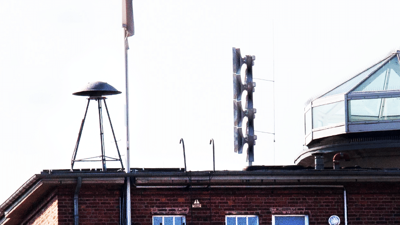
Patrick Drews from accellonet, says, “Using HTZ was an easy choice. We’ve successfully used HTZ in-house for many years to provide fast and accurate results. The results were exported to a GIS for presentation along with the site parameters for planning.”
This project is the first of many planned across Germany. The 88 Mio EUR funding program will finance the replacement systems for up to 16 local authorities. Lessons learned from the installation of this first system provide a strong foundation for future rollouts.
Looking to the next phase of upgrades, accellonet will provide speech transmission index (STI) calculations to measure speech transmission quality. They also propose to improve integration by using geographical information systems such as ArcGIS and with the aid of scripting speed up calculations.
For more information about Sound coverage calculations in HTZ, contact ATDI today.
HTZ simulates and analyses the impact of tropospheric conditions on microwave communications. It provides accurate and reliable predictions of the behaviour of microwave signals in the troposphere using the ITU-R 617-5 propagation model.
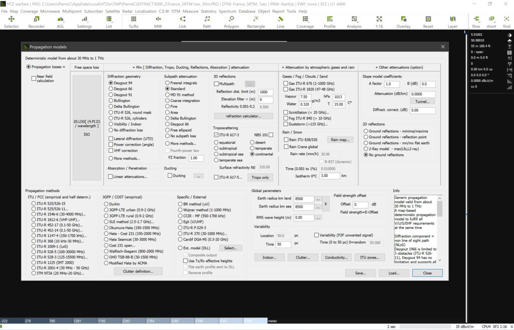
The ITU-R P.617-5 propagation model is the industry standard for analysing and predicting performance across a network. The model accounts for factors like atmospheric conditions, terrain, and transmitting and receiving equipment characteristics, allowing the user to optimise the system for maximum efficiency and reliability. Users can customise the simulation parameters in the model to match the end user’s needs.
This function is used widely by researchers, engineers and network operators. It provides a user-friendly interface and intuitive controls to set up, analyse, and make informed decisions. HTZ supports advanced functions including multiple frequency bands, 3D terrain visualisation, and import/export function of data in various formats.
Join Pierre Coutey, Senior RF Engineer at the upcoming Spectrum Management Summit as he presents a live demo of this function. This two-day event is open to industry and runs on 14-15 February. Registration is required. To enrol, click here.
ATDI releases the population dataset for the Kingdom of Saudi Arabia. This 3-arc-second data is available for download and immediate use in HTZ. The dataset emanates from the 2020 population census which estimates the population per grid cell. The project uses the Geographic Coordinate system, WGS84.
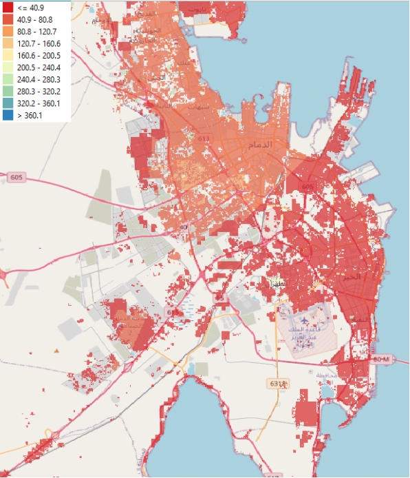
Users with a valid maintenance contract can download this data set from the CRM. Population data supports radio network planning and coverage analysis to ensure densely populated areas achieve the required coverage. For mobile network operators, identifying mobile not-spots or areas without coverage during the planning phase is an essential part of network planning. For more information about this data and other datasets available visit our map data library.


