As we start a new year, we’re pleased to bring you the latest updates on HTZ Communications and Warfare, including new map data enhancements and the upcoming release of the AI Mask Prediction feature, designed to improve data extraction from satellite images, vegetation, and building contours for more precise RF modelling.
This month, we’re showcasing real-world applications of HTZ, including:
Finally, we look forward to meeting you at upcoming industry events—check out upcoming events on where to connect with our team.
These features are available with the latest upgrade (HTZv2025.1) and can be accessed via the CRM. If you do not have a valid maintenance contract and wish to access the latest updates, please contact your local office for more information.
Interface and Reports
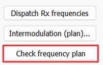 Tx/Rx Parameter Box – Channel Tab: A frequency plan check feature has been added to validate the consistency with the frequency plan attached to the station.
Project Manager – Path Ellipsis Removed: File paths in the project manager no longer include ellipses for better clarity and readability.
Project File Browsing: When browsing project files, the directory containing the attached file opens by default if the filename is defined.
Propagation Models
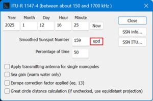 ITU-R P.1147 – Updated SSN ITU Table: Solar Sunspot Number (SSN) indices updated to include values from January 2000 to December 2025.
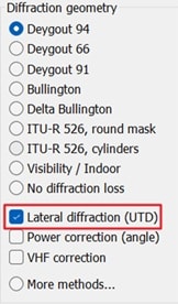 Lateral Diffraction (UTD) – Formula Update: ITU-P.526 equations (67) and (68) have been corrected with new formulas for improved accuracy.
Mobile
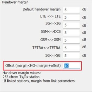 Handover Offset: Handover offset (in dB) added. Handover areas are now identified where the difference between the reference signals (for 3G, 4G and 5G stations) or the RSSI signals (for other technologies) received from the reference station and the candidate station is higher than the handover margin and lower than the handover margin + offset.
Multipoint Station-to-Station Power Field: The nominal power (in W) required to achieve the receiving threshold has been added to the report.
MaXar Server URLs: URLs for MaXar servers have been updated for compatibility.
Check out the latest cartographic datasets released. These royalty-free datasets are a valuable addition to your cartographic toolkit and are accessible to the customer portal. Here's a summary of the data resolutions and their locations: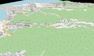
5m resolution - DTM/Clutter/Buildings; Tahiti.
10m resolution - DTM/Clutter/Buildings: Israel.
20m resolution – DTM/Clutter : Liberia. Rwanda + Burundi. Suriname.
25m resolution – DTM/Clutter : North Norway-Sweden-Finland
50m +100m resolution – Population: France + Administrative & postal codes
We continually refresh our map data library to guarantee your access to the most current maps. Stay tuned for updates!
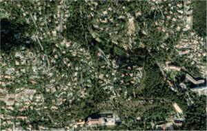
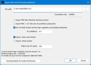
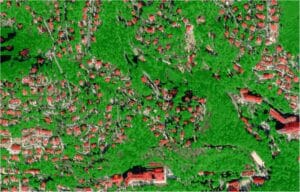
The new AI Mask Prediction function in HTZ introduces a powerful capability to extract and refine cartographic data by leveraging AI-driven algorithms. This feature intelligently processes satellite images, vegetation coverage, and building contours to generate high-quality map datasets.
Enhanced map data quality directly improves the accuracy of RF planning, generating improved coverage predictions, interference analysis, and network optimisation. By automating data extraction and refinement, this function reduces manual effort and ensures engineers have the most accurate environmental inputs for network modelling.
This functionality will be available soon to all customers with a valid Maintenance Contract. Stay tuned for its release.
Fly Chart SRL, a Romanian engineering consultancy, has implemented HTZ Communications to manage network planning for aviation sensors like DME-DME, VOR, and ILS. This move enhances their ability to design reliable and efficient wireless networks while addressing interference challenges.
Aviation systems rely heavily on interference-free communication for safety and operational reliability. HTZ Communications enables Fly Chart to perform coverage modelling, frequency planning, and interference analysis, ensuring robust performance. It also optimises sensor placement, delivering maximum coverage and reliable connectivity while minimising disruptions.
To support their adoption, ATDI provided a training course to familiarise FlyChart’s team with HTZ Communications, enabling quicker and easier deployment of its advanced capabilities.
Nicholas Puscas from Fly Chart noted, “HTZ Communications transforms how we approach aviation networks. Its precision saves time and ensures compliance with industry standards, allowing us to deliver reliable solutions.”
With features like ICAO building compliance, multilateration (MLAT), and indoor modelling for hangars, HTZ helps Fly Chart address terrain changes, infrastructure impacts, and interference. This partnership strengthens FlyChart’s role in delivering safe and efficient aviation networks.
The SOLVIT Systems' advanced Intelligent Search and Rescue (SOLVIT-iSAR™) system has achieved a significant milestone, receiving top honors in a prestigious competition celebrating innovation at CES 2025 in Las Vegas.
 Recognised for its innovative approach to reducing search areas in shadow zones, the system improves rescue efficiency. By integrating coverage & best server analysis, LPS (last position of signal) filtering, time-series inference, and diffusion analysis based on a missing person's mobility model, SOLVIT-iSAR™ can reduce search areas by up to 96%. These features are automated via HTZ Web API within SOLVIT-iSAR’s Radio Coverage Analysis Server, ensuring seamless workflow automation and optimised performance, transforming resource-intensive search efforts into highly targeted and efficient operations.
HTZ Web API plays a crucial role in automating mission-critical RF analysis, by adapting and empowering SOLVIT to address the unique challenges facing search and rescue operations.
SOLVIT Systems will exhibit at MWC 2025, Stand # 4YFN Booth 8.1B31, to demonstrate the SOLVIT-iSAR™ system.

IWCE – 17-20 March – Las Vegas, USA - This premier event brings together professionals from critical communications, public safety, and wireless technology sectors. It offers a platform to explore the latest innovations, network with industry leaders, and gain insights into emerging trends. ATDI looks forward to showcasing our solutions and engaging with experts shaping the future of wireless communications. For registration, click here.
SOFINS – 1-3 April – Paris, France - This event is dedicated to special operations forces and their technological needs. It provides an exclusive platform for showcasing advanced innovations, engaging with defence experts, and exploring cutting-edge solutions tailored to tactical challenges. ATDI’s participation highlights our commitment to supporting mission-critical operations with robust, reliable spectrum management and tactical network planning tools. For registration, click here.


