Welcome to the latest edition of our newsletter, where we share key developments from the ATDI Group.
This issue highlights recent activity from the AFCEA event, where we showcased a collaborative scenario developed in partnership with Griffity Defence and other leading defence partners. This pioneering approach delivers end-to-end solutions for Battlespace Spectrum Management, combining tactical planning, spectrum dominance, and real-time operational insight.
Inside, you’ll also find:
As always, we remain committed to advancing spectrum management through technology, collaboration, and innovation. Thank you for your continued interest and support.
The latest release of HTZ, version V2025.5, brings a wealth of improvements and new capabilities designed to support evolving mission requirements and complex spectrum environments. These updates enhance both user interaction and technical functionality, further reinforcing HTZ’s position as the most advanced platform for spectrum planning and operations.
Interface Enhancements
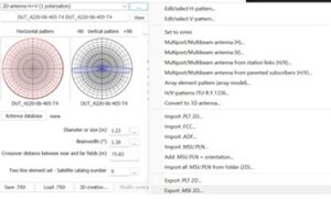
Satellite Functions
HF Propagation
Radiocommunications
Spectrum Management
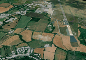
Explore the latest cartographic datasets now available. These royalty-free datasets are a valuable addition to your cartographic toolkit and are accessible through the customer portal. Here's a summary of the data resolutions and their locations:
1m resolution: DTM/Clutter/Buildings: UK: Teesside Airport
20m resolution - DTM/Clutter: Samoa, Jordan.
We continually refresh our map data library to guarantee your access to the most current maps. Stay tuned for updates!

ATDI’s Warsaw office recently welcomed many military personnel to a dedicated product day, showcasing our advanced spectrum management and electronic warfare solutions. Delegates included representatives from the Ministry of Defence, electronic warfare and signals regiments, the Bureau of Frequencies, Special Forces, and counterintelligence units, and ranged from battlefield users to senior officers.
The event demonstrated the deployment of ICS Monitoring for spectrum surveillance and control and showcased HTZ Warfare's battlespace capabilities. Live demonstrations highlighted how these solutions support mission-critical operations, from situational awareness to countering electronic threats.
A key highlight was the introduction of HTZ Web API, designed to integrate seamlessly with any Battlespace Spectrum Management platform. It automates tactical comms, link planning, and EW mission workflows—enabling real-time coordination, rapid scenario modelling, and maintaining operational connectivity across complex, contested environments.
The French Ministry of Defence supported the event, highlighting its interest in strengthening French-Polish relations to leverage mutual benefits.
At this year’s AFCEA event in Bonn, ATDI collaborated with Griffity Defence and other leading system integrators to develop a demonstration scenario. The objective: to show how cooperation between technology providers can strengthen decision-making across NATO’s multi-domain operations.
Set against the backdrop of a coordinated Russian advance through the Baltic region and the strategically critical Suwałki Gap, the scenario highlighted Germany’s contribution to NATO through Brigade 45 “Lithuania,” operational from 2027.
ATDI’s role was to enable spectrum Control in a contested battlespace, focusing on electromagnetic situational awareness and spectrum control—essential for maintaining an operational advantage under complex and congested RF conditions.
Presenting ICS Monitoring SDRN Control RT, ATDI demonstrated:
By enabling NATO forces to observe, orient, decide, and act more quickly than their adversaries, ATDI helped to compress the Observe – Orient – Decide - Act loop and enhance mission outcomes. The solution aligns directly with NATO’s MDO objectives and supports coordinated fire and manoeuvre across operational domains.

ATDI is pleased to contribute to the revised ITU-R Spectrum Monitoring Handbook, specifically Section 5.5, titled "Monitoring of Radar Emissions." This work, authored by Dr Haim Mazar (Madjar), forms part of a broader update to the 2011 edition of the handbook and will be published in the public domain after June 2026.
The updated chapter provides a detailed overview of radar monitoring techniques and measurement principles. It begins with the fundamental principles of radar operation and the radar range equation before outlining the key components of radar systems and their functions. It then examines the wide range of radar applications across civil, defence, meteorological, and space domains, alongside a clear classification of radar types by platform, function, and waveform characteristics.
The chapter also defines the main frequency bands used in radar systems and presents best practices for measuring critical parameters, including RF, pulse characteristics, phase modulation, and unwanted emissions. This technical reference aims to enhance global consistency in radar monitoring and support effective spectrum management.
Note: The ATDI contribution is protected by TIES access. The ITU-R Handbook will be publicly available after June 2026.

ATDI has been shortlisted for the prestigious ICCA Award in the Best Use of Advanced Technology category at this year’s Critical Communications World. Our nomination, Advancing Situational Awareness in Multi-Domain Counter-Drone Operations, recognises the role of electromagnetic spectrum management in protecting military and civilian environments from drone-borne threats.
The submission highlights our real-world operational support, drawing on experience from conflict zones, where ATDI solutions have enabled forces to detect, track, and neutralise drone threats in real time. Our tools deliver actionable intelligence and faster decisions in the most demanding environments by integrating electronic warfare, AI-driven analytics, and automated mission planning.
These same technologies are now applied to critical infrastructure protection, airport security, and public safety. We’re honoured to be recognised alongside leading industry innovators and look forward to the awards ceremony at CCW.
 CCW – 17-19 June 2025 - Brussels Expo, Belgium – Stand L70 - We are delighted to exhibit at Critical Communications World 2024, presenting our latest advances in spectrum management and situational awareness. Visit the ATDI stand to see real-time signal intelligence, automated planning, and AI-powered counter-drone tools in action, supporting both mission-critical and civil operations.
Middle East Rail – 24-25 June – Dubai World Trade Centre – Stand R12 - We’re pleased to exhibit at Middle East Rail 2024, where we’ll discuss how to deliver reliable, interference-free wireless connectivity across complex rail environments. Visit the ATDI stand to explore solutions for spectrum planning, coverage optimisation, and coexistence analysis—key to addressing the region’s evolving rail connectivity needs.


