With summer behind us in the Northern Hemisphere, we’re looking back to some of the highlights from the few past months.
This month’s Newsletter features articles focusing on the growing need to manage the impact of new high-rise developments close to airports and other vital communication services. We also take a sneak preview of an ongoing technical design service for a leading European Air traffic controller. The project involves the design and specification of a DF sensor network to improve airspace safety and increase capacity. We also dive into the rail sector with a high-level overview of activity in this market.
Ensure you don’t miss our latest mapping features and cartography data sets available via the CRM.
As we draw to the close of 2022, so does our events program. If you’ve not managed to meet us face-to-face check out the final few events. If not, reach out to us via the usual channels – let’s connect.
Best regards from
The ATDI team
As our airspace becomes more congested and demand for housing grows, the aviation sector is turning to ATDI to understand the impact of new housing developments on aeronautical equipment in the vicinity of airports.
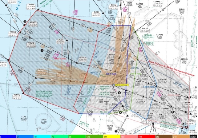
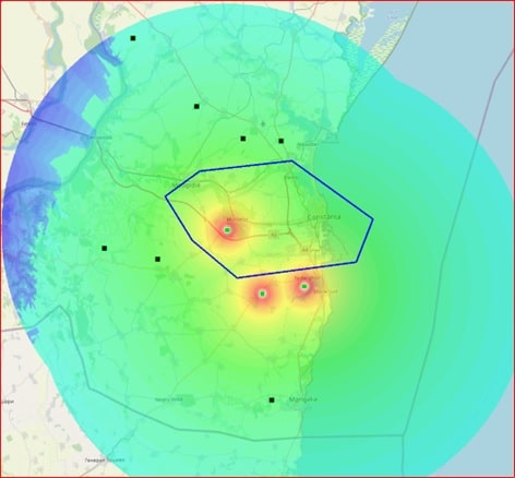
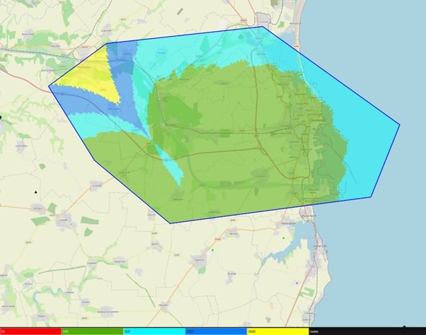
ATDI has been working alongside leading aviation consultants, AGL Aviation to model the impact of proposed new high-rise developments on Israel’s largest airport’s radars and VOR stations. A joint working group saw representatives from AGL, the national civil aviation authority and the airport authority define the project scope and identify the format for outputs. The studies looked at the impact on primary surveillance radars, secondary surveillance radars and VOR stations.
Radar calculations were performed at different altitudes from the target: for example, 800 ft. (243.8m) / 1 500 ft. (457.2m) / 2 000 ft. (609.6m) and 2 500 ft. (762.0m) AMSL. For the VOR station, calculations were undertaken at different altitudes of aircraft: for example, 2 000 ft. (609.6m) and 3 000 ft. (914.4m) AMSL.
The operational areas around the airport were displayed as SHP polygons. The airport authority supplied map data for the airfield which was reconstructed directly in HTZ Communications. The overall study area was covered by maps supplied by ATDI. ATDI overlaid the proposed new buildings onto the map for modelling. Before and after scenarios were used to compare the difference based on a ‘worst-case’ scenario.
Conclusions identified the impact the new building/s had on the area covered at each target height considered for coverage differences greater than 1dB.
AGL Aviation
AGL Aviation are dedicated aviation consultants. Their services enable stakeholders to manage operational challenges, regulation (compliance, development) and infrastructure developments (from initial plans to design and from airspace to airports). So whether that’s a new airport that needs to be unified into the existing airspace or a real-estate project that needs to be built below aviation infrastructure, AGL provides expert advice on how to manage and mitigate risk and guarantee project success.
Air traffic manager ROMATSA turned to ATDI to help manage Romania’s airspace.
ATDI is undertaking a coverage study and technical design service to enable the installation of a nationwide radio direction finder sensors (DF) network. The study aims to identify the optimal number of sites and locations for the installation of the DF sensor network.
The ATDI team will identify the best locations for direction finders from a database of sites supplied by various stakeholders. With the potential site locations defined, the DF equipment parameters are imported into HTZ, including antenna heights. ATDI will undertake DF coverage calculations, which are overlaid on a localised map to analyse their accuracy. For areas with poor coverage, additional site locations will be identified. During the site searching phase, potential new DF sites are identified. ATDI undertakes site surveys by modelling prospective coverage for the proposed new locations, with the results overlaid on a localised map to ensure accuracy.
The outputs from the study are a list of potential DF locations and associated antenna heights, plus DF coverage maps and a DF localisation accuracy map. The modelling is completed in HTZ Communications.
Romatsa
Romania’s air traffic controller steps up to growing pressure on how they manage their airspace. This project aims to optimise air traffic control operations by increasing capacity. Air traffic controllers identify targets corresponding to a flight in the VHF band with targets on the radar screen. By implementing direction finders, Romatsa can identify aircraft quicker, so improving response times and reducing risk.
Demand for a DF sensor network emerged in response to Romatsa’s management of the South East Europe Free Route airspace agreement, part of which determines the flight areas (hot areas) and the radar targets corresponding to them. Added to that, their management of the impact of COVID-19 on air traffic volumes and the re-routing of aircraft due to restrictions imposed by the war in Ukraine has also presented problems.

With pressure growing on our road networks and increased costs for air travel, both the public and logistic companies are turning to the railways. For over three decades, ATDI has worked in partnership with rail network operators, system integrators and consultants to ensure our rail networks meet the growing challenges facing the industry.
TETRA for rail comms
Leading system integrator, Sapura Malaysia has been operating for over 40 years and has subsidiaries across the rail and aviation industry, oil and gas, defence and security.
Since 2018, ATDI has supported Sapura's vital critical comms for their rail projects by providing HTZ Communications, training and technical support. Sapura designed a TETRA network for train-to-ground communications to support vital emergency calls. HTZ Communications was used to study uplink and downlinks, analyse network traffic using population data and assess handovers. To ensure the network meets the required coverage, HTZ simulates radio coverage along the route, identifying areas where optimisation is required. Similarly, drive test data can be imported directly into HTZ to provide a real-life understanding of the network reach.
Private-LTE supports Aussie outback
Transporting goods in rural Australia is only achievable using trains or trucks. ATDI supplied Vodafone with a private-LTE network design to support their customer with their supply chain operations. The project covered three main areas: baseline design evaluation, link budget assessment and network optimisation.
Transforming Railway comms - Poland
Poland completed a nationwide GSM-R network & mission-critical backhaul network to improve railway security and reliability.
ATDI formed part of the PKP consortium providing support across three key project areas: design of the country-wide backbone transmission network, support for the network infrastructure rollout including the framework to connect radio objects with the PKP infrastructure and the upgrades to the operator’s VHF networks. This last phase entailed the colocation of base stations to support both networks, to reduce equipment and infrastructure costs.
Modernizing the Railways down under
Long-term customer, Sydney Trains operates routes across New South Wales. For the past decade, ATDI has provided technical support services and software solutions. During the initial GSM-R network rollout, ATDI completed the network dimensioning during the trial stage, which included propagation model tuning, site search, coverage, traffic, and handovers. To support this project, ATDI delivered HTZ Communications licenses and 5m resolution cartographic data along the NSW rail service corridors. The project vendors UGL Limited and Huawei also implemented HTZ for network deployment, design and optimisation.
Since the original network rollout, ATDI has evaluated the impact of new structures on comms along the rail lines and incoming coordination assessments for new mobile (4G/5G) services within the restricted boundaries of the GSM-R network.
Sydney Trains use ICS manager to manage their spectrum licenses across TETRA, GSM-R and MW. ICS Manager enables the operator to manage radio assets, license status analysis, notifications, change-log management, and statistical reporting for billing management.
ATDI continues to provide coverage and modelling reports for key areas across the network, ensuring Sydney trains stay on track.
Sydney Trains
Sydney Trains operates rail services across the metropolitan Sydney area plus the Rail Operations Centre and the maintenance of assets including tracks, trains, signals, overhead wiring, stations and facilities. Sydney Trains maintains trains and a large proportion of the infrastructure used by NSW TrainLink.
.


