HTZ Communications offers advanced radio network planning and optimisation capabilities for almost every technology from a few kHz to 1 THz. This integrated solution manages the entire radio planning lifecycle.
For over three decades, it has been the choice of spectrum regulators, critical communications and telecom operators, providing an unmatched degree of precision and quality for users.
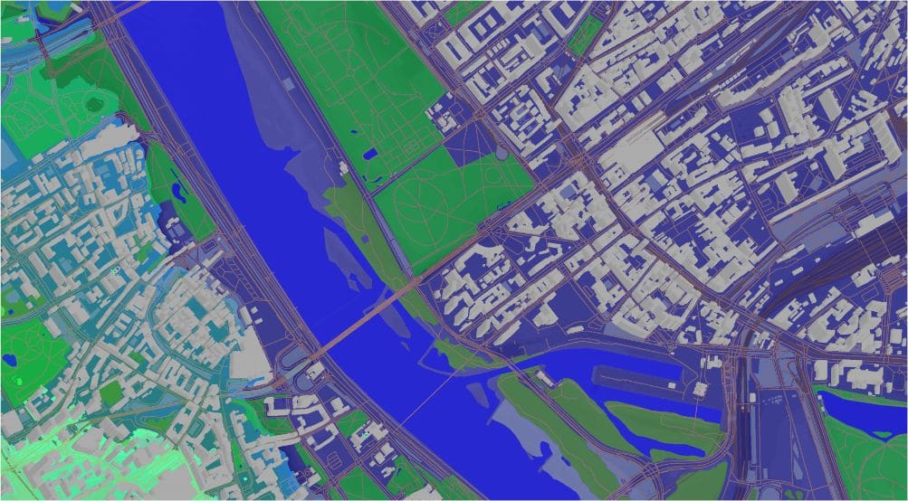
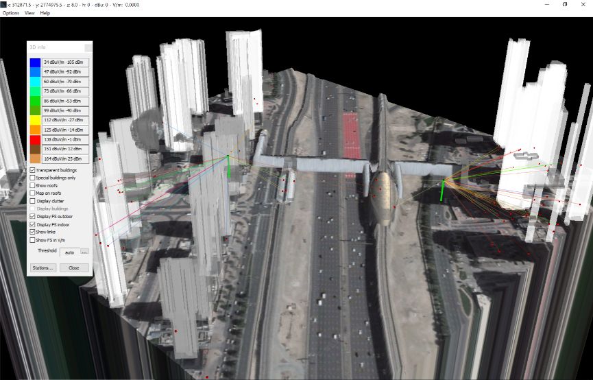
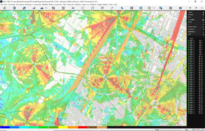
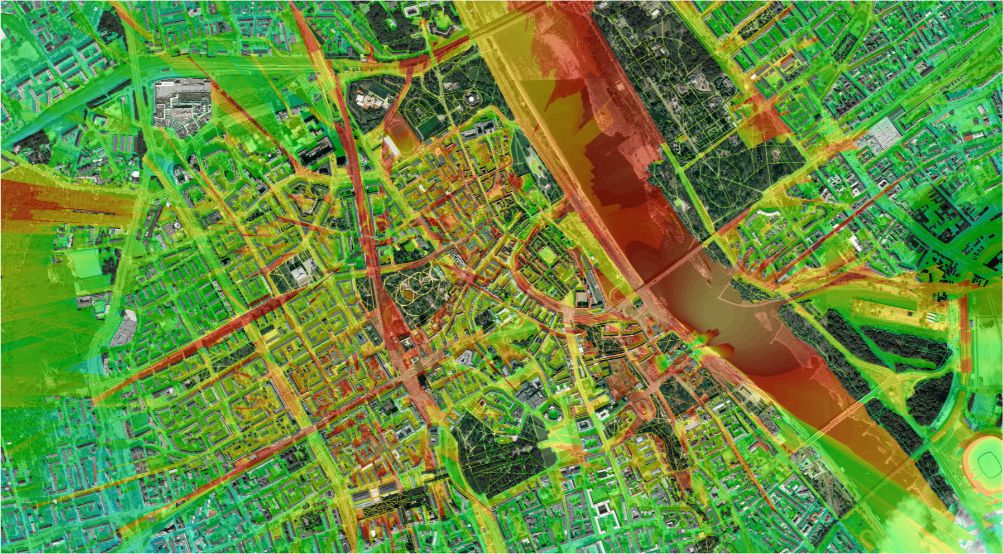
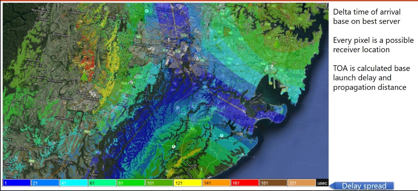
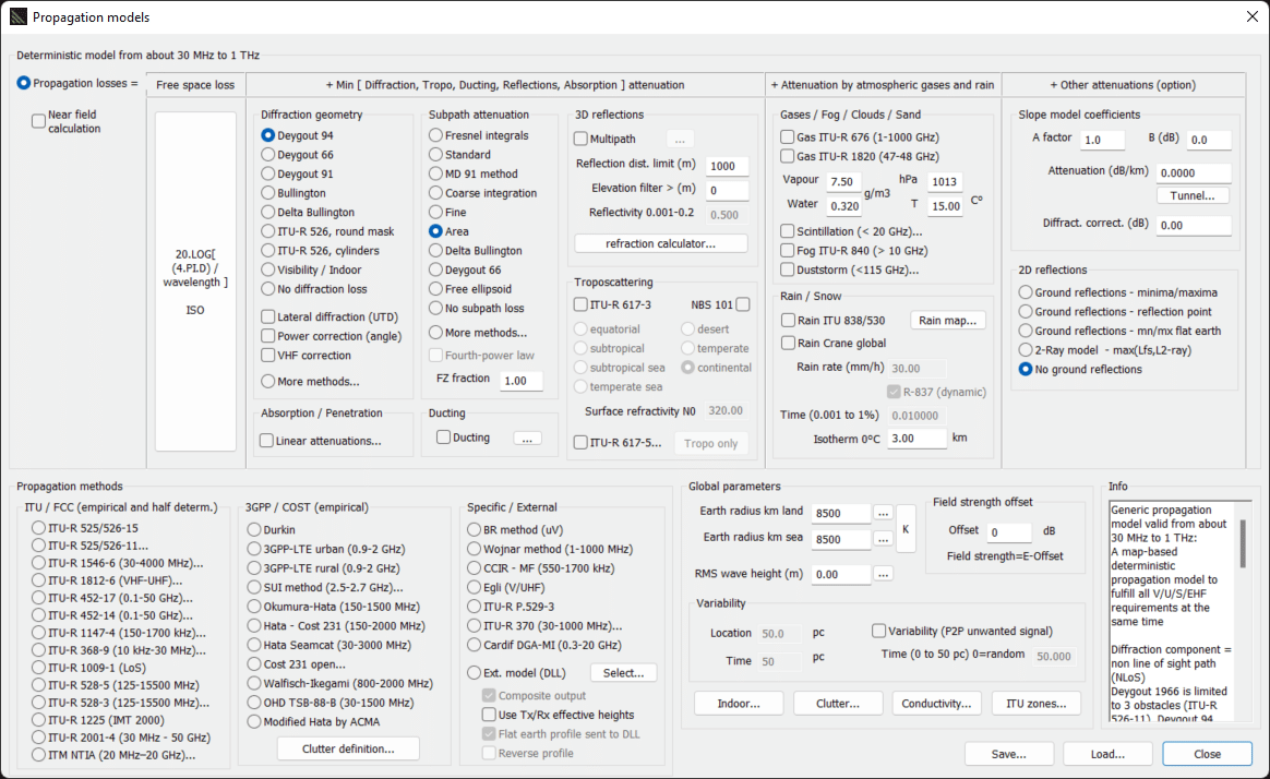
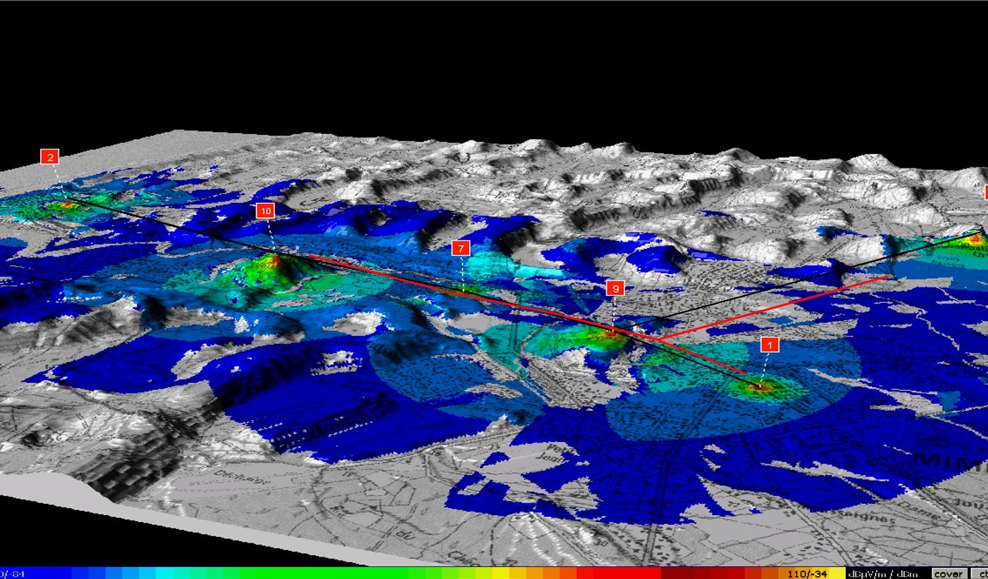
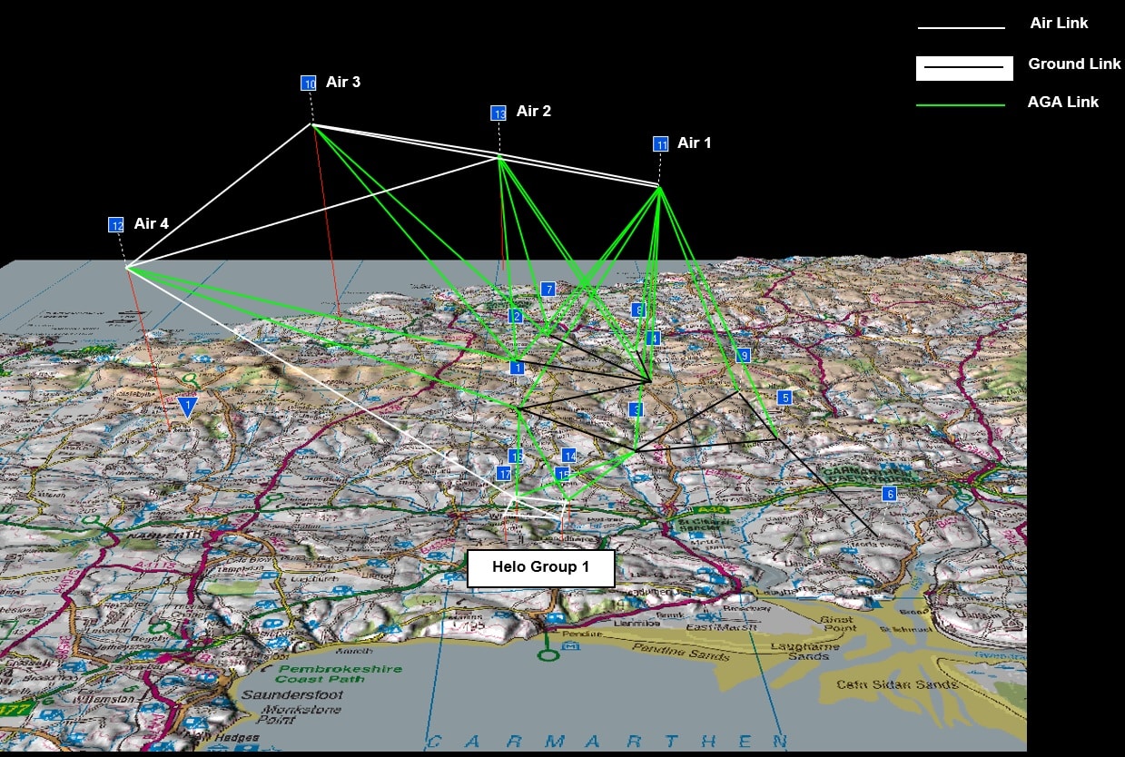
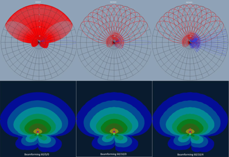
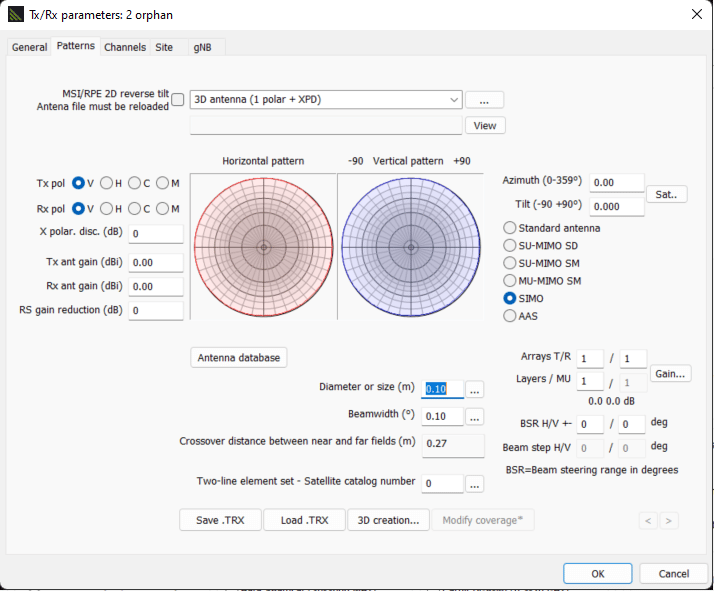
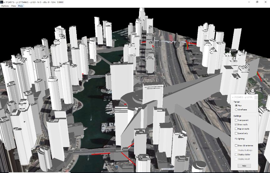
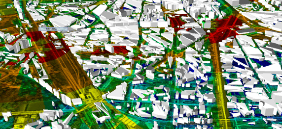
HTZ features a comprehensive propagation engine which supports the design of outdoor, indoor, and outdoor-indoor networks. It supports a library of over 50 empirical, deterministic and hybrid propagation models, including all ITU-R models, Okumura-Hata, Cost-Hata, Irregular Terrain Model-Longley Rice, ITU and 3GPP models.
HTZ Communications replaces ICS Telecom. ATDI offers an upgrade to any perpetual license users of ICS telecom to the latest version of HTZ communications.
HTZ Communications supports every stage of the radio network lifecycle and continues to add value once the network goes live. The key features include:
Trial licenses are available on request
ATDI offers licenses in discounted packs for Universities and Research departments.
ATDI offers licenses in discounted packs for Universities and Research departments.
Online: requires an internet connection to access a standalone or server license
Offline: no internet connection is needed to access a standalone license
USB key: online software download with access via a hardware dongle
Virtual Machine: access via end-user VM or cloud-based server options


We recommend the following hardware specification to run HTZ communications / HTZ Warfare:
Processor: x64 multicore (Intel™ I7 or better CPU) with 4 cores minimum
Memory: min. 16 GB or more
Graphics adapter: memory of 2 GB, OpenGL compatible, Full HD Display (1920 x 1080 minimum). UHD recommended
Graphic card: 2 GB, OpenGL compatible, Full HD (1920*1080 minimum)
AI: Nvidia card recommended (GPU)
Hard disk: SSD 1 TB or more. Storage: 2 TB
Internet access for map download and access to the online library
Microsoft Office™ x64
X64 Operating systems: Windows™ 10, Windows™ 11, Windows Server™ 2012, Windows Server™ 2016, Windows Server™ 2019, Windows Server™ 2022, Windows Server™ 2025.
NB. FIPS encryption compatible.
Memory: 16 GB and more
Processor: x64 multicore (Intel® I7 or better CPU) with 4 cores minimum
Hard disk: SSD 1 TB or more. Storage: 2 TB
x64 multicore (Intel™ I7 or better CPU) with 4 cores minimum
Internet access (for map download and access to the online library)
Graphics card: 2 GB, OpenGL compatible, Full HD (1920*1080 minimum). UHD recommended.
AI: Nvidia card recommended (GPU)
x64 OS Operating systems: Windows™ 10, Windows™ 11, Windows Server™ 2012, Windows Server™ 2016, Windows Server™ 2019, Windows Server™ 2022. Windows Server™ 2025.
NB. FIPS encryption compatible.
Reliable map data is essential to support radio network planning. ATDI offers high-quality royalty-free digital maps to customers with a valid maintenance contract. This data is sourced from various resources, including SRTM, LiDAR data, Ordnance Survey, Corine land cover, and Open Street Maps.
HTZ allows users to integrate their custom propagation models into the software. For more information, please contact support@atdi.com
Our software supports the complete network lifecycle including network design, planning and optimization. It allows engineers to model coverage from outdoor into indoor spaces and indoor to indoor, providing seamless coverage for end users.
ATDI offers Universities access to HTZ Communications licenses at a competitive price. Licenses can be hired for the academic year according to the numbers required. For the price of the packs available, please contact your local office.
U-Pack 5: for 5 simultaneous users
U-Pack 10: for 10 simultaneous users
U-Pack 25: for 25 simultaneous users
The educational packs include access to a dedicated server license, which allows a maximum of simultaneous users depending on the pack purchased.
HTZ Warfare licenses are available for military research agencies and training schools for students wishing to complete their thesis, providing this thesis offers contributes to developing a subject or theory for the telecom market.
Contributing over three decades of research and development to our software solutions, we can't be accused of standing still. Over 90% of our customers have now migrated to HTZ and are reaping the benefits from the improved user interface and user experience. Most importantly, the biggest advantage is the reassurance and support they get from their maintenance contract. This allows users to access all the latest HTZ releases including beta versions, get help from the technical support desk and access our comprehensive map data library. Contact your local office to discuss your upgrade today.
As part of the upgrade from ICST to HTZ, we now use soft key activation codes. These are installed in the software directory for standalone licenses or on the server. The license options for these are listed below:
Standalone licence/s: This licence is attached to one standalone PC or laptop. Once the licence has been activated, it remains attached to the computer where the activation is initiated. No other application or software tool is required for set-up. A standalone licence allows each user to operate up to three instances of the software (CALs) at any one time.
Server licence: A Licence Server Management Tool needs installing and the server licence must be activated on that Server. The Client computer will then connect to the server to activate their local license. Any computer connected to the LAN can use HTZ, with the number of concurrent users or sessions equal to the number of licences available. A server licence allows each user to activate one instance of the software (CAL) per licence at any one time.
Our software supports a plethora of propagation models. For the latest released version, contact our support helpdesk.
Deygout 1994
Deygout 1991
Deygout 1966
Bullington
Delta-BullingtonDiffraction
UTD3D Multipath: Ray-tracing and Lambertian reflections2D reflections: minima/maxima, reflection point, 2-ray model
Absorption (dB/km, mix Diffraction/absorption…)
ITU-R P.617-3
ITU-R P.617-5
ITU-R P.676-12
ITU-R F.1820-0
ITU-R P.840-8
ITU-R P.530-18
ITU-R P.837-7
ITU-R P.838-3
Crane
ITU-R P.525-4
ITU-R P.526-15
ITU-R P.526-11
ITU-R P.1546-6
ITU-R P.1812-6
ITU-R P.452-17
ITU-R P.452-14
ITU-R P.368-9
ITU-R P.1147-4
ITU-R P.528-3
ITU-R P.528-5
ITU-R P.2001-4
ITM-NTIA (Longley-Rice)
Durkin3GPP-LTE (urban/rural)
SUI
Okumura-Hata
Hata Seamcat modified
Hata Cost 231
Cost 231 open
OHD TSB-88
Hata modified by ACMA
Wojnar
Egli
ITU-R P.529-3
ITU-R P.370-7
Cardif (HTZ warfare only)
ITU-R P.533-13
African Broadcast
FCC 98
3GPP-LTE
Johnson-Gerhardt IF77
ITU-R M.1225-0
ITU-R P.2109-1
ITU-R P.2040-2
TSB-88
NBS 101
ITU-R P.618-13
ITM 122
Walfisch-Ikegami
Vigants
...
ATDI offers a choice of software hosting options. Our users adopt a desktop solution (standalone) or through LAN-server license or VPN (server) or via the end-user Virtual Machine (VM) or cloud-based server options (cloud).
We offer two licensing options: perpetual license for indefinite use and hire licenses.
Users can download the software onto as many machines as required. This software is activated in two ways:
Standalone license: This version is fixed to a standalone PC or laptop. Once the license has been activated, it remains attached to the machine where the activation is initiated. No other software application is required for set up. A standalone license allows each user to operate three instances of the software (CALs) at any one time.
Server license: This option requires a License Server Management Tool to be installed and the license must be activated on that Server. The Client computer then connects to the server to activate their license. Any computer connected to the LAN can use the software, with the number of concurrent users or sessions equal to the number of licenses available. A server license allows each user to activate one instance of the software (CAL) per license at any one time.


