The railway communications industry underpins safe, efficient, and connected rail operations. From train control to passenger services, reliable telecom networks are essential. With growing demands for capacity, cross-border operations, and digital transformation, operators require advanced tools to plan, optimise, and future-proof their networks—supporting technologies like GSM-R, LTE-R, and the transition to FRMCS.
Key industry challenges include ensuring seamless tunnel and station coverage, managing interference in densely trafficked corridors, upgrading legacy infrastructure, and meeting strict safety and regulatory requirements.
Radio Network Planning
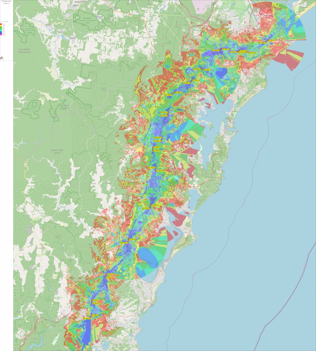
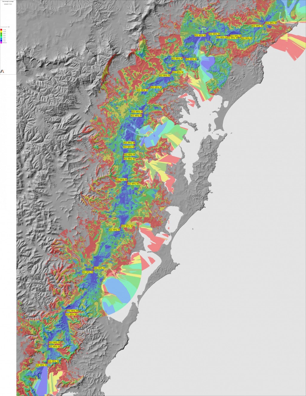
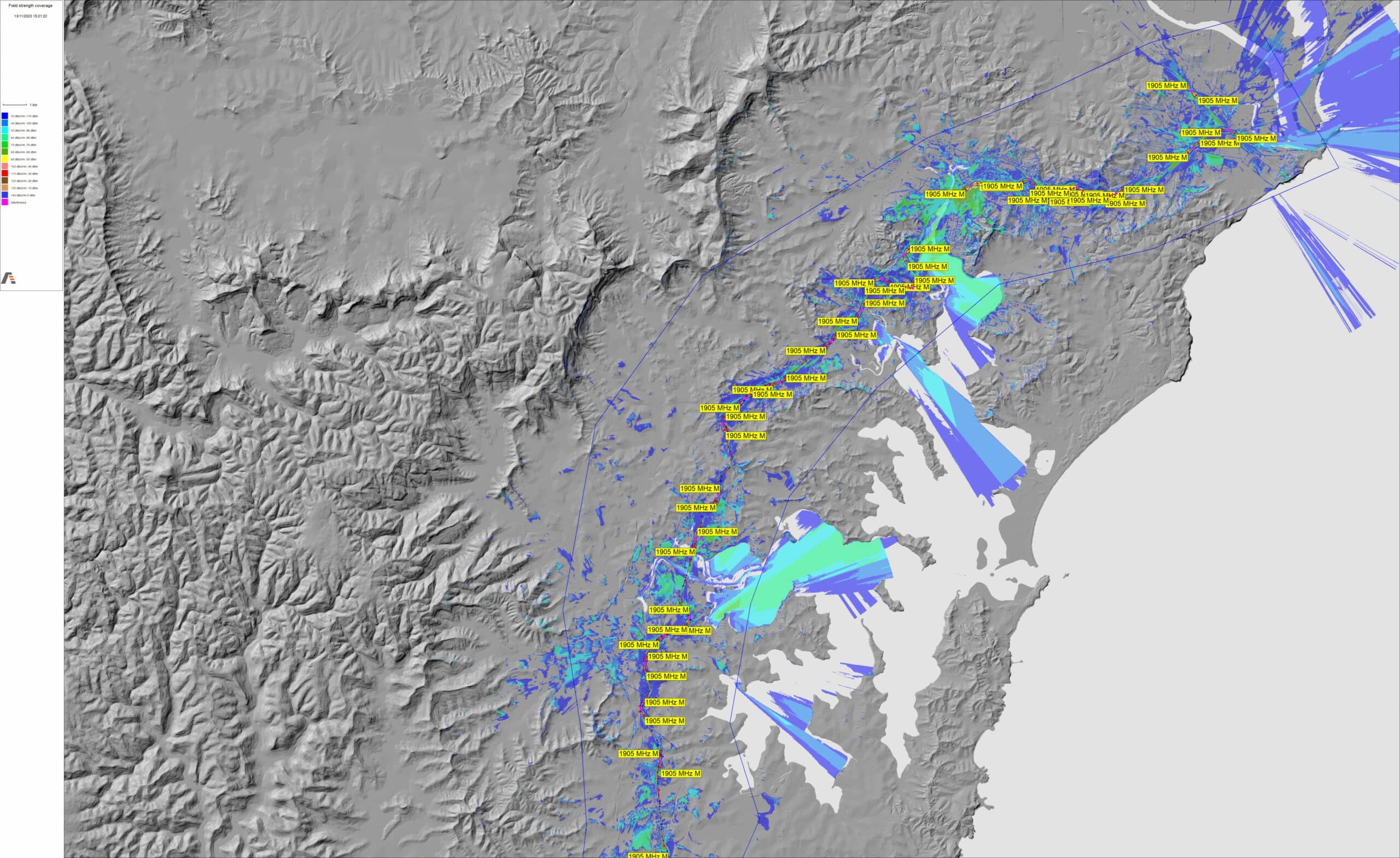
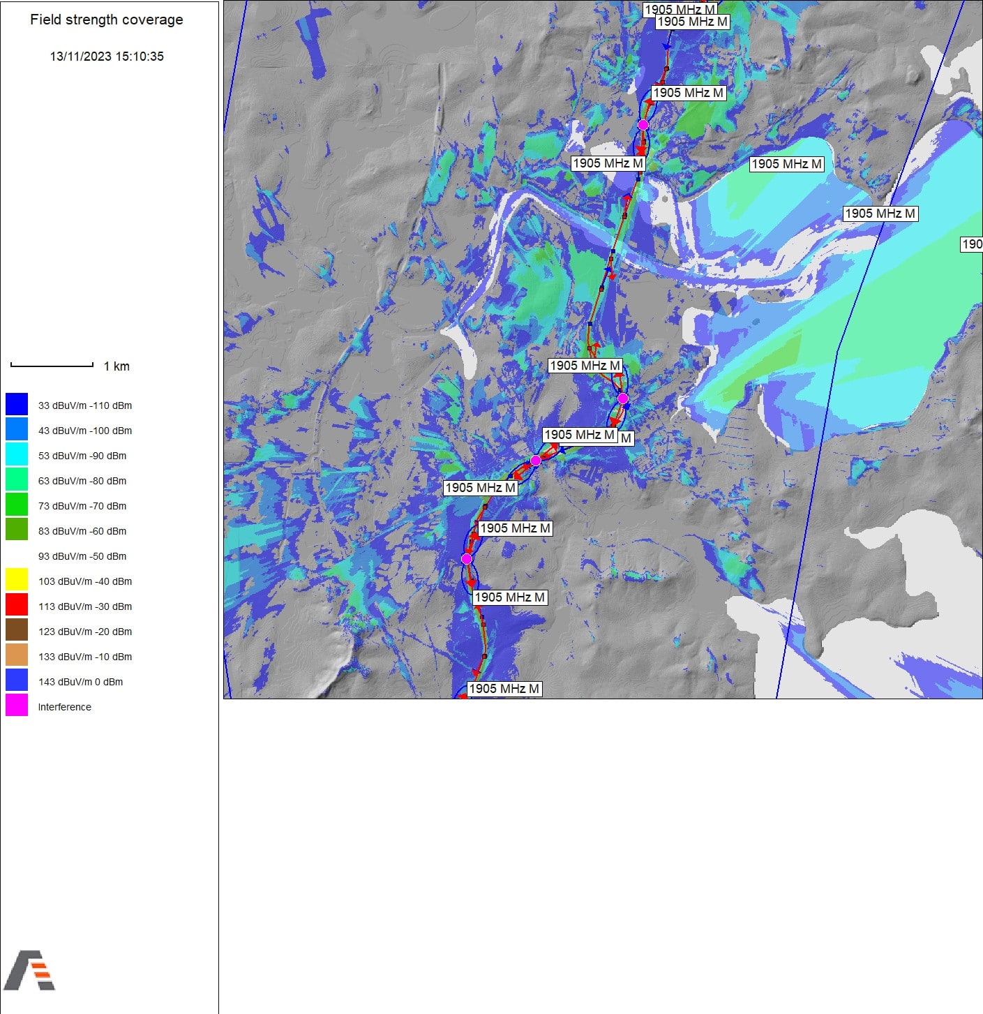
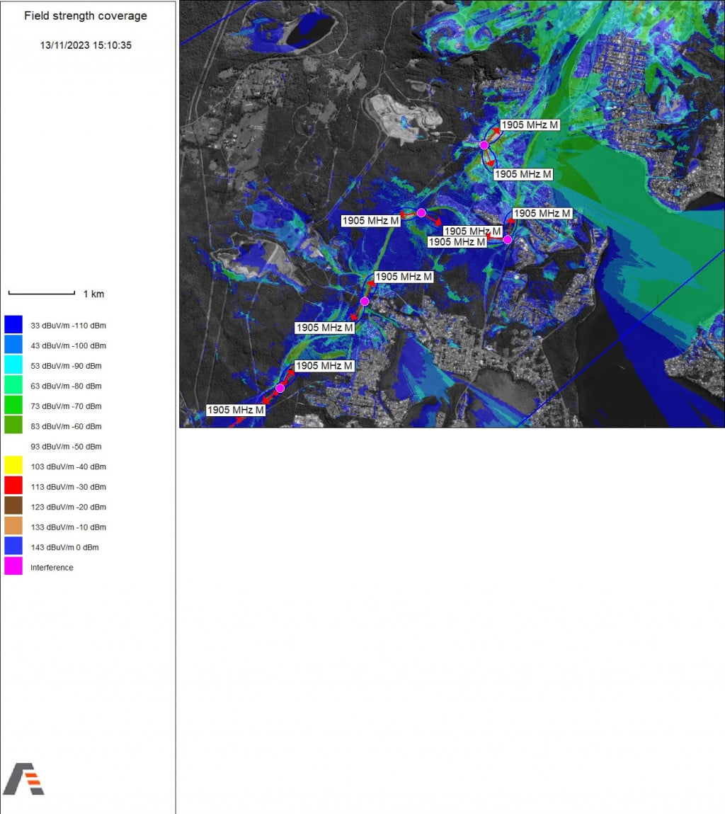
Plan and model RF coverage for GSM-R, TETRA, LTE-R, FRMCS and more, ensuring reliable voice and data communications along rail corridors.
Interference Analysis
Identify and mitigate co-channel, adjacent-channel, and intermodulation interference across critical and non-critical networks, including cross-border issues.
Infrastructure Modelling
Simulate the impact of terrain, tunnels, cuttings, stations, and bridges on signal propagation to maintain consistent coverage.
Microwave Link Design
Perform line-of-sight checks, Fresnel zone clearance, and link budget calculations to design robust backhaul systems for voice and data.
Coverage Prediction
Accurately forecast signal reach and quality for outdoor, indoor, and tunnel environments using deterministic propagation models.
Mobility and Handover Analysis
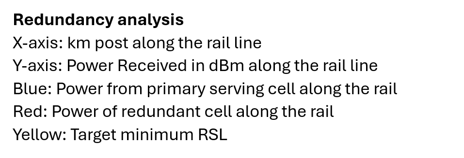
Analyse network performance during train movement and assess risks of call drops or weak zones at high speeds or tunnel points.
Automatic Frequency Planning
Allocate channels based on spectrum availability, usage patterns, and interference levels—automating a complex, time-consuming process.
Capacity and Throughput Forecasting
Dimension networks for future demands by simulating traffic loads and estimating required TRx capacity based on user density and application needs.
Real-World Calibration
Utilises measurement data to refine propagation models and enhance simulation accuracy in real-world deployment conditions.
Cross-Border Coordination
Model and coordinate networks that span national boundaries to ensure compliance, prevent interference, and optimise spectrum use.
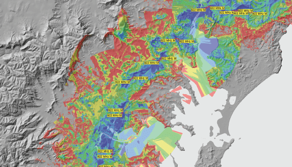
GIS and Cartographic Integration
Leverage high-resolution mapping, satellite imagery, and topographic data to model real environments and streamline RF planning.
Vendor & Equipment Integration
Import data from site surveys and coordinate with vendor equipment parameters for seamless planning and deployment.
Environmental & Safety Compliance
Evaluate exposure risks and conduct safety assessments in line with standards like ICNIRP and Natura 2000 directives.
ATDI’s flagship software, HTZ Communications, delivers a robust, all-in-one solution for planning, designing, and optimising mission-critical communications across rail networks. With full-spectrum support from a few kHz up to 1 THz, HTZ enables network engineers to manage DMR, TETRA, P25, LTE-R, and FRMCS technologies on a single, unified platform.
HTZ combines a deterministic modelling engine with advanced GIS integration to simulate accurate radio coverage in both indoor and outdoor environments, ensuring signal resilience along complex rail corridors. It supports end-to-end network lifecycle management, including:
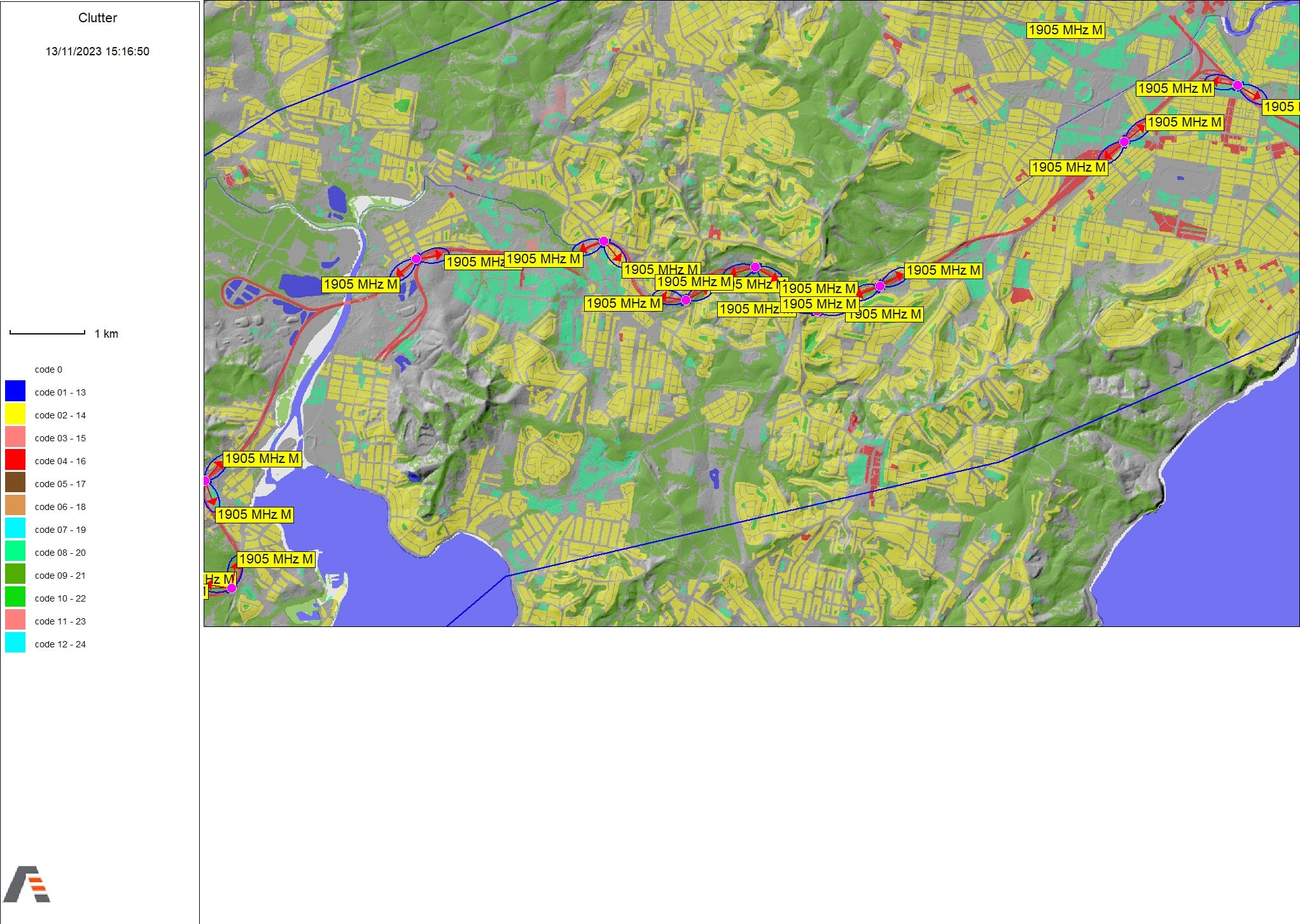
Coverage analysis along tracks, stations, tunnels, and viaducts
Site selection and infrastructure impact assessments
Cross-border coordination and automated frequency planning
Interference mitigation across legacy and next-generation systems
Real-world calibration, via correlation between predictions and field data
Rail operators rely on HTZ to identify and eliminate coverage gaps, reduce interference risks, and ensure seamless coexistence between narrowband and broadband technologies. By proactively modelling network behaviour and environmental effects, HTZ enables safe, reliable, and future-proof communications for rail transport systems.
Adopted by defence, emergency services, and public infrastructure authorities worldwide, HTZ Communications is the trusted choice for designing and maintaining interoperable, high-performance rail networks.
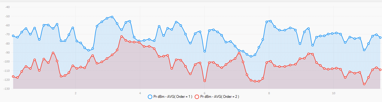
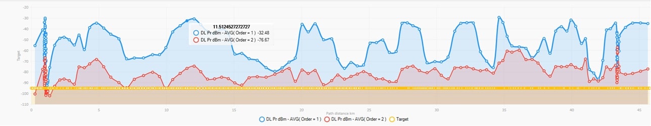
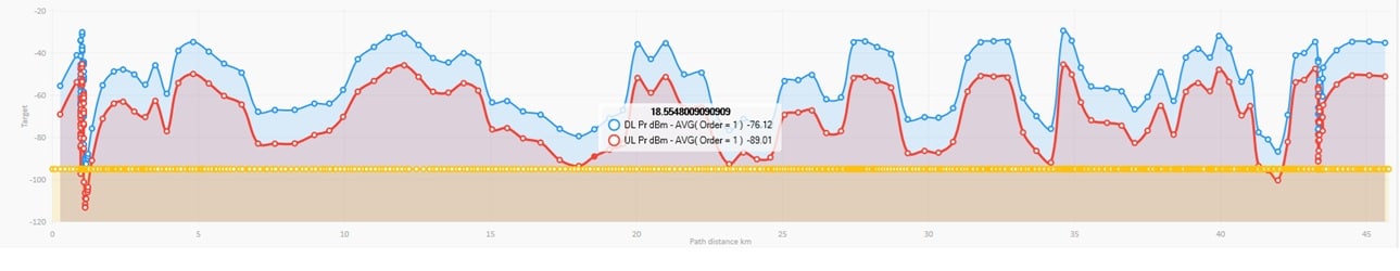
Simulates and predicts radio signal behaviour with precision along rail corridors, ensuring consistent coverage in all environments.
Evaluates the effect of tunnels, bridges, and urban clutter on network performance to plan for real-world challenges.
Identifies the best base station locations for maximum coverage and operational efficiency across the rail network.
Analyse and mitigate interference across multiple technologies, including GSM-R, FRMCS, DMR, LTE, and MNOs.
Ensures high-speed, reliable connectivity by modelling performance for throughput and quality of service requirements.
Plans, analyses, and manages all major radio technologies within a single, unified platform.
Evaluates network behaviour during train movements and at tunnel entry/exit points to maintain seamless communication.
Enhances model accuracy by calibrating predictions against real measurement data collected in the field.
Keep coverage maps synchronised with network changes using live integration with GIS and network management systems.
Tailored support for planning, analysis, and optimisation across critical communications networks.
ATDI offers consultancy services across the whole network lifecycle—from planning to optimisation. Railway operators, integrators, and regulators rely on our expertise for mission-critical communications. With decades of rail experience, our engineers deliver accurate RF studies, network dimensioning, and customised support tailored to the unique challenges of railway environments.
Access detailed terrain, clutter, and building data for accurate and reliable radio network modelling.
HTZ Communications incorporates a powerful GIS engine for processing detailed cartographic data, which is essential to rail planning. It supports satellite images, aerial photos, and scanned maps to model tracks, tunnels, cuttings, and bridges. Users can access royalty-free maps from ATDI’s library or import and convert their datasets directly into the tool for accurate network modelling.
End-to-end MW planning, including link budget analysis, interference checks, and path profile validation.
For mission-critical communications, a resilient, high-capacity backhaul is vital for continuous service. HTZ Communications equips engineers with powerful tools to plan, analyse, and manage microwave (MW) links between remote sites and central hubs. It supports line-of-sight verification, Fresnel zone clearance, link budget analysis, and interference assessment—even in dense urban or complex terrain. Integrated GIS and terrain modelling reflect real-world obstructions, enabling the design of redundant, robust MW networks that meet the demanding performance and reliability standards of modern control room operations.