ATDI provides wireless connectivity solutions to remote oil, gas, and mining facilities worldwide. Our radio systems are designed to deliver reliable and resilient communications, even in the most challenging environments.
Platforms, refineries, and mines use a combination of radio technologies to ensure comprehensive coverage for short- to medium-range communications, supporting onsite personnel, offshore rigs, and support vessels. Digital radios are increasingly adopted to enhance call clarity, extend coverage, and enable advanced features such as data transmission, messaging, and GPS tracking.
For long-range connectivity, where terrestrial networks are unavailable, remote sites often rely on satellite communication systems. To maintain seamless operations, all these radio systems must be interoperable, enabling effective communication between diverse teams and vessels.
ATDI’s flagship RF engineering software, HTZ Communications, is designed to streamline the planning, modelling, and optimisation of secure and resilient wireless networks. Supporting all radio technologies from a few kHz to 1 THz, HTZ enables the simulation of multiple radio technologies within a single project. This allows operators to effectively plan, model, and optimize their networks while mitigating the risks of communication failures.
Key features include:
HTZ is an integrated RF solution that manages the entire radio network lifecycle. Its comprehensive propagation engine, powered by recognised ITU propagation models, ensures precise modelling for all technologies. HTZ supports every stage of the network lifecycle—from initial scoping to full network optimisation—providing unparalleled versatility.
Additionally, HTZ offers specialised features designed for onshore, offshore, and remote site applications:
Comprehensive Propagation Library
The integrated library includes both deterministic and empirical models, allowing users to simulate various radio systems across indoor, outdoor, and mixed indoor/outdoor scenarios. Key features include automated propagation model tuning and seamless integration with external models for enhanced flexibility.
Best Server Location
Identify the optimal location for antennas, including azimuth and elevation settings, to maximise network performance.
Prospective Planning
Plan and evaluates coverage based on predefined criteria across all supported technologies, ensuring alignment with network objectives.
Impact Analysis of Moving Stations or New Structures
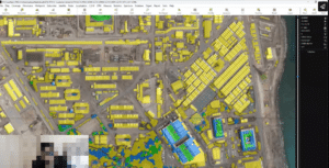
Analyse the effect of moving a station or introducing new buildings or obstacles on network coverage. Simulations are visually overlaid on Google Maps for better context and decision-making.
Radio Network Modelling
Create detailed network models in both 2D and 3D formats, offering a comprehensive view of network design.
Interference Analysis
Conduct advanced interference analysis to ensure network reliability and optimal performance.
3D Reflections and Signal Loss Modelling
Model signal attenuation in complex environments, including outdoor-to-indoor transitions and the effects of signal absorption. This includes the analysis of signal penetration losses and their impact on overall network coverage.
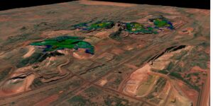
Automated Network Planning for Smart Mines
Automate coverage calculations based on terrain changes and integrate key RF functions such as best server identification, composite coverage, and overlap analysis. This is particularly useful for dynamic environments like smart mines.
Automated Coverage Planning
HTZ enables automatic identification of the best locations for base stations by integrating advanced propagation models, site acquisition tools, and traffic analysis. This is crucial for optimising coverage and identifying shadowing or black spots, as demonstrated in its automated site planning and optimisation functionalities.
Automated Frequency Assignment
With its sophisticated frequency planning capabilities, HTZ minimises interference while ensuring robust communications. The software supports automated frequency assignments, which are critical for maintaining communication integrity in dense or high-demand environments.
DL and UL Throughput Maps
HTZ includes DL (Downlink) and UL (Uplink) analysis tools, providing detailed traffic data insights. These maps help assess network performance and identify capacity shortfalls, guiding decisions on whether additional sites are needed.
Antenna Modelling Capabilities
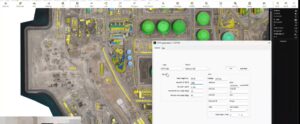
The software offers robust tools for modelling antenna heights above sea level. This ensures optimal signal propagation and coverage, supported by GIS-based cartographic layers for precise visualisation.
Design Support for Offshore Platforms
HTZ supports the planning and deployment of broadband access networks for offshore platforms and associated assets, addressing specific challenges such as environmental factors and remote connectivity needs.
3D GIS Support
The integration of 3D GIS capabilities allows accurate ray-tracing and high-frequency network modelling. This feature is particularly advantageous for urban or complex terrains, ensuring precise coverage predictions.
Coexistence Analysis
HTZ excels in analysing frequency impacts on sensitive equipment, such as radars, ensuring compatibility and preventing interference. Its coexistence analysis is tailored to meet ICAO standards and other international regulatory requirements.
Automatic Network Optimisation
Through tools like automated site optimisation and Monte Carlo simulations, HTZ identifies the best configurations for antennas, including adjustments to their heights, to enhance network performance while reducing interference.
Additional Features
RMS Wave Heights and EMF Exposure
The software computes environmental factors such as RMS wave heights and evaluates electromagnetic field (EMF) exposure, aiding in compliance and safety analysis.
HTZ integrates with GIS survey solutions to import and convert updated maps automatically, enabling accurate network planning and optimisation. It continuously calculates coverages affected by terrain changes, ensuring automated systems operate reliably. Essential RF functionalities like server optimisation and coverage analysis further enhance network performance.
For more information, visit our Use cases.
The use of CCTV and other cameras to safeguard vital oil and gas facilities is steadily rising. ATDI has introduced cutting-edge features into HTZ, enabling it to detect, recognise, and identify a given camera's capabilities. Explore our latest video showcasing how HTZ effectively manages a camera object in a simulated environment.
Explore this video, which showcases how HTZ effectively manages a camera object in a simulated environment.
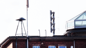
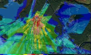
Discover how a German engineering company uses HTZ to model sound propagation for digital sirens, identifying key sound blockers during the planning phase. This use case explores how electronic sirens enable power control, adjust signal direction, and manage speech transmissions. HTZ simulates how sound propagates from the replacement system, ensuring accurate planning.
For full information visit our use cases.